Field type: geoshape
In the form designer, click + Add visible field, choose geo... as the field type, and then choose geoshape as the type when editing the field details.
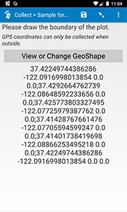
geoshape: collects GPS coordinates that form a polygon enclosing an area, using maps and the device's built-in GPS support. You can easily view the collected polygons in SurveyCTO's Data Explorer, or export them, with the rest of your data, for use in outside GIS systems.
Identifying shapes on maps generally requires an Internet connection, but see this help topic for an advanced option to load offline map tiles.
In the spreadsheet form definition:
| type | name | label |
| geoshape | fieldname | question text |
Android usage instructions
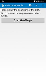
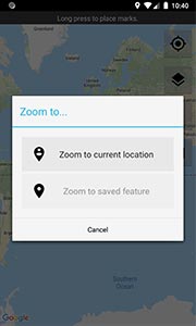
Upon reaching a geoshape form field, begin the collection process by pressing the "Start GeoShape" button. This will load a world map and prompt you to choose where in the world to zoom ("Current location" is usually the best choice, unless editing data collected earlier). Once you have zoomed to the correct location on the map, long-press on the map to drop a pin and begin creating the shape. Long-press again at another location on the map to drop another pin and connect the points so far. Then, long-press to drop additional points along the desired boundary.
Each dropped pin will connect to the last one, and the last pin will also connect to the first, in order to close the polygon. If you make a mistake, you can long-press on an existing pin to pick it up and drag it to a new location. Click the trash-can button to clear and start over, or the disk icon to save and exit. (See screenshots here...)
Web usage instructions
Web forms do not currently support geoshape fields; if you test or fill out a form on the web, these fields will fall back to just collecting a single GPS position. If your project requires better web forms support, please let us know by going to the Support Center and either opening a support request or posting a message in one of the community forums.
Default hint
On mobile devices, geoshape fields have a default hint that appears in italics below the label you specify: "GPS coordinates can only be collected when outside." If you want to specify a different hint (perhaps in a different language), you can specify your own text for the field's hint.


