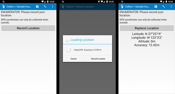
Field type: geopoint
In the form designer, click + Add visible field, choose geo... as the field type, and leave the type set to geopoint when editing the field details.
geopoint: collects GPS coordinates using the device's built-in GPS support (or the web browser's location service). Indicate "maps" in the appearance column to immediately show the captured location on a map or "placement-map" in the appearance column to show the location and also allow the user to manually adjust that location using a pin (both map options generally require an Internet connection, but see this help topic for an advanced option to load offline map tiles).
Alternatively, specify "background" in the appearance column to invisibly record the user's location in the background.
On mobile devices, SurveyCTO Collect will keep trying to acquire a more accurate GPS reading until it reaches a specific accuracy threshold (by default: +/- 5m accuracy). If you use the "background" appearance, Collect will keep trying to read the location until it reaches that target accuracy or the user exits the form, whichever comes first; if not using "background", users can manually stop the process and accept the current level of accuracy at any time. If you would like to use a different accuracy threshold than 5m, just specify the number of meters in the accuracy_threshold column (for example, "1" to keep trying until 1m accuracy is reached, or "10" for 10m accuracy; only applies when form filled on mobile devices).
In Collect's Admin Settings, you can also change the default accuracy threshold from 5m to 10m, and, on Android, you can control which location provider is used to read GPS positions. If you have a device that has difficulty achieving 5m accuracy, you can try switching the default provider and/or the default accuracy threshold.
In the spreadsheet form definition:
| type | name | label | appearance | accuracy_threshold |
| geopoint | fieldname | question text | ||
| geopoint | fieldname | question text | maps | |
| geopoint | fieldname | question text | placement-map | |
| geopoint | fieldname | question text | background | |
| geopoint | fieldname | question text | background | # |
For more information on other GPS data collection options, GPS performance tips, or advanced options for offline map support, see Collecting GPS data. (As long as your device has a GPS sensor, you can generally collect geopoint data offline. It's just the "maps" and "placement-map" appearance options that require maps – and therefore special considerations for offline use.)
Default hint
On mobile devices, geopoint fields have a default hint that appears in italics below the label you specify: "GPS coordinates can only be collected when outside." If you want to specify a different hint (perhaps in a different language), you can specify your own text for the field's hint.

